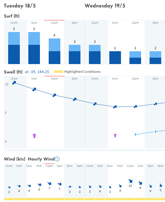
Currently 13, clear sky, at Bells Beach Victoria

Presented by

How to read a surf forecast and pick where to surf

There is a wide variation of factors to consider when analyzing a surf forecast and ultimately where to surf on any given day.

The most simple breakdown of this would include swell, wind and tide. Getting these right collectively, could provide you ideal conditions for an enjoyable surf. However get them wrong and the chances of having fun are greatly diminished.

Surf Report

A surf report is a representation of the current weather and atmospherical conditions for a specific location at a given moment. It is often presented with various graphs and charts, concentrating on the strength and direction of both swell and wind.

If you are lucky enough, your local break may even have an active Surf Cam to give a live visual image of the conditions to take all the guess work out of it.

Surf Forecast

The Surf Forecast is the deeper data lying behind the Surf Report.

In short the Surf Forecast is a prediction on what the Surf Report is going to look like.

The surf forecast is produced from computational analysis derived from data collected via Ocean Buoys and weather satellites, normally condensed into a series of charts or a colour-coded map.

Whilst these forecasts aren’t to be taken with 100% accuracy, it can provide you with a good idea as to when the best window for surf will be.

Without getting too scientific, lets break down the major variables to consider so that you may increase your chances of having better surfs and ultimately spending more time in the water.

Wave/Swell Height:

This factor tells us how big the waves are going to be. In summary, how big the biggest wave is expected to be. It is often given in a range of feet or metres.

For example, 3-5ft or 1.5-1.7m. This can often give you a great idea of which beach to surf at, exposed beaches will receive more swell than protected ones.

A key point to note here is that different swell forecasting sites use different measures of wave height.

Some will use wave face height (generally US based sites) and others will use the “Hawaiian” system which is best described as the back of the wave to the peak of the wave (Eg. A 3ft wave will actually have a 6-7ft wave face, or is about head heigh).

Image: Surfline.com

Image: Surfline.com

Wave/ Swell Period:

This will often indicate the power of the waves. Groundswells tends to bring periods of 10-20 seconds are are typically stronger, where as wind swells are weaker at 0-10 seconds.

Swell Direction:

A no brainer this one; the direction from which the swell is coming. Normally expressed via a cardinal point (N,S,E,W) or specific degrees.

Generally speaking beaches that face the direction of the swell will get bigger waves.

Wind Speed and Direction:

Wind is the primary factor in wave and swell formation. It also can greatly affect the wave structure and quality. There are three main terms to understand for wind direction for any given beach.

Offshore, Onshore and Cross-shore. These name are self explanatory. Offshore means the wind is blowing away from the shore, this will help to keep the wave face clean and hold for longer before breaking.

The reverse for onshore, winds blowing towards the beach tend to ruin the wave face quality and hold for less.

Cross-shore wind means the wind is blowing across the beach and is typically accompanied with chops along the wave face.

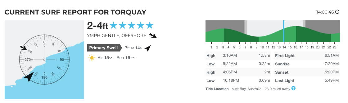
Moon Phases and Tides:

A full or new moon will create higher high tides and lower low tides. When the moon is in its earlier stages, such as quarter moon, the differences between low and high tides will be much smaller.

Tides tend to affect certain breaks differently. At some spots, when the tide is too low waves close out. At others when the tide is too high, waves won’t break until too close to the shore.

Knowing which tide your given break works best on will help you to pin point the best window to surf, when combined with a good analysis of the surf report and forecast.

Here is a snippet of a surf report for Bells Beach from Magic Seaweed. It shows the direction the beach faces with a compass for reference.

As the beach predominantly faces south east, we know that an ideal offshore wind would be coming from the north west. This report labels it as offshore for us, noting the light strength of 3mph.

Photo: Magic Seaweed

Photo: Magic Seaweed

Another variable depicted here is the size, period and direction of the swell. 3.5 feet at 15 seconds indicates a good groundswell is present.

With the direction of the swell coming form the SSW, shown on the compass pointing directly at the coastline of Bells.

Immediately looking at this report (taken around 10am) how would you expect the surf conditions to look? Personally I’d be packing the car and getting out there asap.

Here is great video that deep dives into the science behind wave creation and how to read a forecast:

Just getting into surfing and want some more helpful hints and tips?

Check out our subscriber blog on Equipment Selection for Beginner Surfers Here

Got a question you want our coaches to answer? Put it in the comments box below!

Don’t forget to follow up on socials to stay up to date with what we are up to and who we are working with!

Facebook & Instagram

Leave a Reply

Your email address will not be published. Required fields are marked *